The Joyce Lake DSO Iron Ore Project is Century’s most advanced project and in December 2022 the Project Feasibility Study was published on SEDAR. An Environmental Impact Study, in compliance with federal and provincial issued guidelines, is also being prepared.
Project Summary
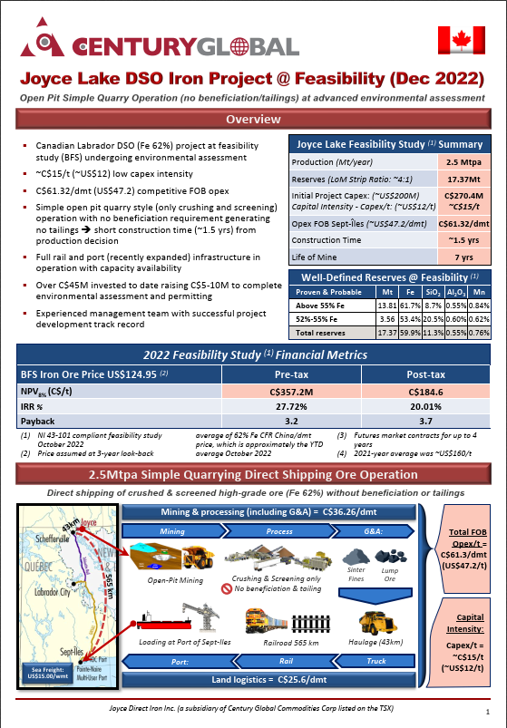
- Open pit mine delivering high grade iron ore to the crushing and screening plant, while stockpiling lower grade ore for crushing and screening at the end of the open pit life.
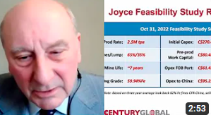
- Ore dry crushing and screening generating 65% sinter fines and 35% lump products at a total of 2.5 million dmt annually with an average grade of 59.94% Fe.
- Approximately 7 years production and year-round products transportation to markets with fines products transported in summer and previously dried lump products transported in winter.
- Products transported over a 43km dedicated haul road from the mine site to a new rail siding near Astray Lake, which connects to an existing rail-line for transport to the Port of Sept-Îles Multi-User port at Pointe Noire, for shipment to China and other world markets.
| Project Facts (December 13, 2022) | ||
| Location | In Labrador ~20km NE of Schefferville, Quebec | 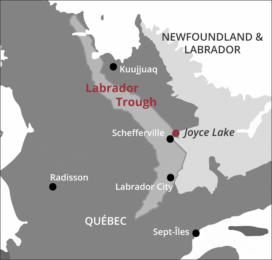 |
| Mineral Resources (50% Fe Cut-off) | ||
| Deposit Type | DSO | |
| Measured & Indicated | 23.97 million tonnes | |
| Inferred | 0.83 million tonnes | |
| Feasibility Study | ||
| Before Tax | After Tax | |
| NPV at 8% discount rate | C$357.2 million | C$184.6 million |
| IRR | 27.72% | 20.01% |
| Years to Payback (from start of operations) | 3.2 | 3.7 |
| Initial Project CAPEX | C$270.4 million | |
| Average Project OPEX | C$61.32/dmt (FOB Pointe Noire) | |
| Life of Mine | Approximately 7 years | |
| Strip Ratio | 4.25:1 | |
Mineral Resources and Reserves
The mineral resources and mineral reserves are reported in accordance with Canadian Institute of Mining, Metallurgy and Petroleum (CIM) definition standards for Mineral Resources, Mineral Reserves and their Guidelines, and are compliant with NI 43-101.
| NI 43-101 Mineral Resource Estimate (May 6, 2022)1 | |||||
| Cut-off 50% Fe2 | Tonnes3 | % Fe | % SiO2 | % Al2O3 | % Mn |
| Measured (“M”) | 18,530,000 | 58.71 | 12.97 | 0.55 | 0.81 |
| Indicated (“I”) | 5,440,000 | 58.35 | 14.09 | 0.51 | 0.53 |
| M+I | 23,970,000 | 58.63 | 13.22 | 0.54 | 0.75 |
| Inferred | 830,000 | 62.10 | 8.30 | 0.43 | 0.78 |
| Mineral Reserves (May 6, 2022)4 | |||||
| Category | Tonnes | % Fe | % SiO2 | % Al2O3 | % Mn |
| High Grade Proven (Above 55% Fe) | 11,320,000 | 61.65 | 8.72 | 0.55 | 0.84 |
| Low Grade Proven (52% – 55% Fe) | 2,840,000 | 53.49 | 20.42 | 0.62 | 0.69 |
| High Grade Probable (Above 55% Fe) | 2,490,000 | 61.51 | 9.46 | 0.50 | 0.61 |
| Low Grade Probable (52% – 55% Fe) | 720,000 | 53.27 | 21.68 | 0.59 | 0.29 |
| Total Reserve (Above 52% Fe) | 17,370,000 | 59.94 | 11.28 | 0.55 | 0.76 |
|
|||||
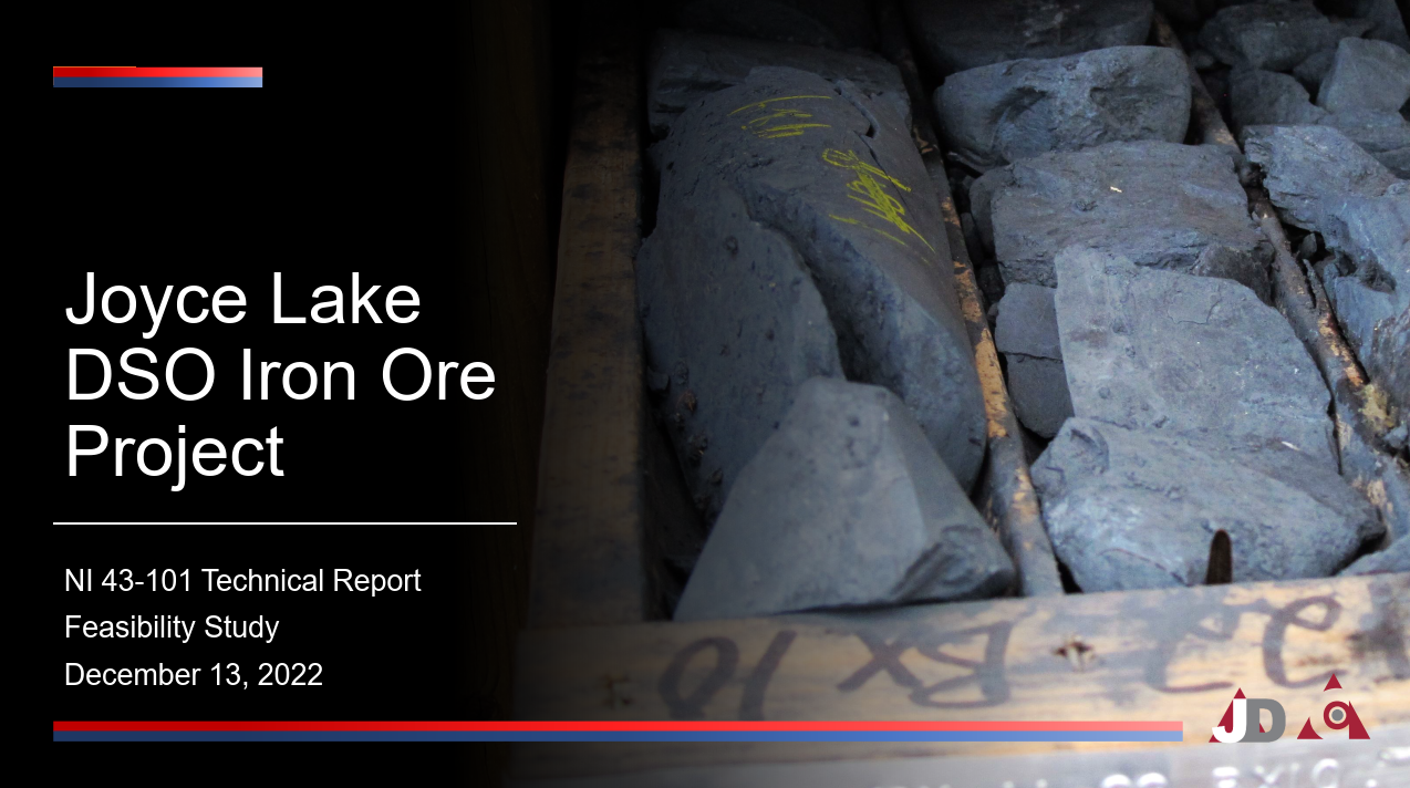
Technical Report
NI 43-101 Technical Report – Feasibility Study for the Joyce Lake DSO Iron Ore Project![]()
Property Description and Ownership
The Joyce Lake Property consists of six mineral licences located in Newfoundland and Labrador, 100% owned by Joyce Direct Iron Inc. (which is 89.8% owned by Century).
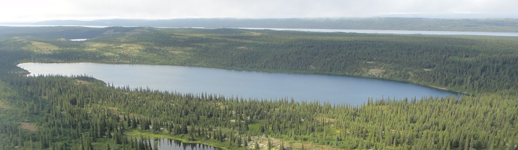
The Property is located 20 kilometres northeast of Schefferville, Québec, in the province of Newfoundland and Labrador. The Schefferville area is characterized by a sub-arctic continental climate with mild summers and very cold winters. This area is in the boreal forest with low rolling hills rising from 600 to 700 metres above sea level.
Location, Access and Infrastructure
The Joyce Lake DSO Project is located in the western part of the Labrador Trough iron range, about 1,200 kilometres northeast of Montréal and 20 kilometres northeast of the town of Schefferville. There are no roads connecting Schefferville to western Labrador or elsewhere in Québec. Access is by rail from Sept-Îles or by air from several.
The Joyce Lake project is located on a peninsula in Attikamagen Lake directly across Iron Arm Inlet from the exploration camp which is accessible by gravel road from Schefferville. The Joyce Lake project is only accessible by boat or float plane in summer or over the ice from Iron Arm camp in winter.
The modern airport at Schefferville has a 2,000-metre paved runway and navigational aids for passenger jet aircraft. Air service is available three times per week from Wabush, Labrador, with less frequent service to Montréal and Québec City, via Sept-Îles.
The existing rail network that connects Schefferville to the Port of Sept-Îles consists of two sections: the northern section of railway from Schefferville to Emeril Junction (~205km) is owned by Tshiuetin Railway, and the southern section from Emeril Junction to the Port of Sept-Îles is owned by QNS&L Railway (~360km).
Background Geology
The Iron Arm-Attikamagen Lake area is located northeast of Schefferville, Québec, and is part of the much larger area which includes the Schefferville Mining District. The underlying rocks in the area form the western, miogeosynclinal part of the Labrador Trough in the Churchill Province of the Canadian Shield. These rocks are mainly sedimentary strata of early Proterozoic (Aphebian) age.
Field mapping indicates that the fold structure at Joyce Lake is trending NW-SE. There are zones of minimal strain and the units appear undeformed. These low strain zones are of particular interest because they would represent unshortened and therefore thicker iron beds outside of the fold nose. It was observed in the field, especially from the massive hematite units on one limb of the fold structure, that there were specularite and hematite veinlets and tension gashes (1-3 millimetres) oriented obliquely to the strike of the perceived bedding. These brittle features likely helped to accommodate the volume change during shortening and thus the shortening to be oriented along a strike of NE-SW.
The Ruth shale provides an impermeable layer at depth to cap the down flow of meteoric water and therefore encourage leaching of silica and the deposition of enriched hematite as DSO. This is expected to be greatest where there is the greatest brittle deformation and would carry the greater tonnage where the massive hematite units are thicker. These conditions are satisfied within the nose of the fold structure and within the minimal strain zones identified in the field. The fold structure plunges to the southeast and one would expect the hematite beds to thicken.
Despite IOC’s thorough exploration of the Schefferville area in the past, the relatively new discovery of the Joyce Lake DSO Project suggests that further DSO potential exists. Recent drilling and 3D modeling have shown that the DSO deposits located on the property have a predictable geometry and potential for tonnage additions, both within the known extents and extrapolations. All of the mineralized structures have been modeled for the first time, providing a far better understanding of the geological context and inter-relationship among structures.
Feasibility Study
Project Description
The mining plan is based on continuous operation over 365 days per year, 7 days per week, and 24 hours per day. The starter pit was designed to avoid excavation close to Joyce Lake during pre-production and construction phases. The open pit nominal production rate is 2.5 M dry tonnes per year of iron ore lump and fines products at an average grade of 60% to 62% Fe.
The primary equipment fleet includes 96-tonne diesel haul trucks, 11 m3 diesel-hydraulic shovels, 11 m3 front-end loaders and 200 mm DTH blast hole drills.
Financial Evaluation Assumptions
- Long term price, CFR China of US$124.95 dmt 62% Fe fines.
- The average FOB Sept-Îles operating cost is C$61.32/dmt (US$47.10/dmt) before royalties. Ocean freight to China is assumed to be C$33.93/dmt (US$26.06/dmt). Total landed (China) cost is C$95.26/dmt (US$73.16/dmt).
- Royalty payments average C$1.86/dmt.
- Exchange rate of US$0.77 per C$1.00.
- Life of mine of approximately 7 years.
- Initial capital cost estimate accuracy of -10% / +15%.
| Summary of Initial Capital Cost Estimate | C$millions |
| Mining (Capitalized Pre-Stripping) | $20.7 |
| Mining Equipment (Initial Owner Fleet) | $26.3 |
| Infrastructure Direct Costs | $143.1 |
| Infrastructure Indirect and Owners Costs | $42.8 |
| Railcars Lease Down Payment | $9.2 |
| Other Mobile Equipment Lease Down Payment | $10.0 |
| Sub-Total | $252.0 |
| Contingency | $18.4 |
| Total | $270.4 |
The initial capital cost estimate of $270.4 million excludes estimates of closure costs of $6.4 million, sustaining capital of $18.3 million and salvage value of $31.8 million and certain leasing and pre-payment costs to secure transportation infrastructure capacity. These estimates are included in the feasibility study financial evaluation.
| Summary of Estimated Operating Costs | C$/dmt |
| Mining | $15.46 |
| Pit Perimeter Dewatering and Water Management | $0.70 |
| Crushing and Screening and Product Handling | $3.02 |
| Product Truck Haulage to Astray Lake Rail Loading | $6.71 |
| Load-out and Rail Siding Load-out and Rail Siding at Astray Lake | $1.81 |
| Site Administration | $4.52 |
| Site Services (Room & Board and FIFO Air Tickets) | $3.15 |
| Lump Drying | $0.89 |
| Rail Transportation, Port and Shiploading | $25.06 |
| Total | $61.32 |
Project Video – Quick Facts
 |
Century Announces Feasibility Results for the Joyce Lake DSO Project | Peter Jones (opens in a new window) |
 |
The Key Parameters of Joyce Lake | Peter Jones (opens in a new window) |
 |
CEO Sandy says innovative transport strategy improves fundamentals for Joyce Lake (opens in a new window) |
 |
All you need to know about Joyce Lake by Chairman Peter Jones (opens in a new window) |
Project Presentation
 |
Click here to download our current project presentation (opens in a new window) |
Project Teaser
 |
Click here to download our current project teaser (opens in a new window) |